
9/19/11, Noon – We are open for business again!!! In a nutshell, everything at Sawbill and east is open. All the roads and entry points west of the Sawbill Trail and east of the fire are still closed.
Here are some details: As of tomorrow, Tuesday, 9/20/11 the Sawbill Lake wilderness entry point is open, with travel restricted to routes north and east of Sawbill Lake. Baker Lake, Homer Lake and Brule Lake entry points are also open.
Also, starting tomorrow, the Sawbill Lake Campground, Crescent Lake Campground and Baker Lake Campground are open.
The Sawbill Trail will be open, the Grade Road (FR 170, the road to Brule, Crescent, etc.) will be open.
The Kawishiwi Lake and Hog Creek wilderness entry points will remain closed. All the roads going west off the northern half of the Sawbill Trail will remain closed.
The ban on open fires continues until further notice. Fires are banned in all of northeastern Minnesota right now. Grills and stoves are allowed.
We’ll post more details here as they become available.
Author: Sawbill
9/19/11, 7:30 AM – We received 6/10ths of an inch of rain yesterday.
9/19/11, 7:30 AM – We received 6/10ths of an inch of rain yesterday. It would have been a welcome event in any case, but it should deal a major blow to the Pagami Creek Fire. That said, it is possible that the fire could revive itself, but the chance of that happening diminish with each day that we advance toward winter. – Bill
9/18/11, 7 PM – It has rained off and on all day.
9/18/11, 7 PM – It has rained off and on all day. The rain gauge reads .52″ of an inch so far and it’s still raining.
Dennis Neitzke, District Ranger for the Gunflint District of the U.S. Forest Service, sent some pictures that he took from the air near Polly Lake yesterday. – Bill

Looking at Polly Lake from the south end looking mostly north. Townline Lake is the small lake in the middle of the picture. Picture taken 9/17/2011.

Also south of Polly Lake, but looking more to the west. The north end of Kawasachong Lake is on the left side of the picture, Polly is on the right and Townline in the middle. Picture taken 9/17/2011.

Looking almost due west from south of Polly Lake. Wolverine Lake is in the upper right. Picture taken 9/17/2011.
Rain, rain, blessed rain.
9/18/11 – Rain, rain, blessed rain. About 6:30 this morning, I was pleasantly awakened by the sound of rain on the roof. A steady, cool, widespread rain has been falling for several hours now. With the days ahead getting shorter, cooler and more humid, this rain should go a long way to assigning the Pagami Creek Fire to the history books. It’s sure possible that the fire could kick up again, but the odds of that happening are diminishing by the hour. Yay!
The Forest Service will be meeting tomorrow to talk about lifting some of the road, campground and wilderness entry point closures. Of course, we’ll post any changes here as soon as we hear about them.
I can’t say thank you enough to everyone who contacted us to offer help, moral support and encouragement. I also can’t begin to express my gratitude to the Forest Service, Cook County Sheriff’s department, Minnesota conservation officers, Border Patrol and everyone else who has been working so hard to keep us all safe. – Bill
Yesterday was another beautiful, quiet day at Sawbill.
9/17/11 – Yesterday was another beautiful, quiet day at Sawbill. We went about our normal chores while keeping a nervous eye on the wind and the sky. It was warmer and breezy, but the Pagami Creek fire continues to be fairly dormant. The fire boss was quoted yesterday as saying “The fire is taking a nap right now, but we don’t know what kind of mood it will be in when it wakes up.”
Today’s forecast is for sunny skies, warmer temperatures and a pretty brisk south wind. This will keep the fire from advancing toward Sawbill, but may drive it north into some of the canoe routes that are commonly accessed from Sawbill. We’ll just have to wait and see…
Here is this week’s edition of Cook County’s West End News from WTIP, North Shore Community Radio. – Bill
9/16/11 9:45 AM – We just received this from the Forest Service.
9/16/11 9:45 AM – We just received this from the Forest Service. It is a total fire ban on the Superior National Forest, both in and out of the BWCA Wilderness:
FYI: The decision has been made to change campfire restrictions on the Superior National Forest.
This means that two previous Supervisor’s Orders will be terminated: one regarding campfire use in the BWCAW and one regarding campfire use on national forest lands outside of the BWCAW.
In their place ONE new Order goes into effect at 12:01 am on Friday, September 16, 2011.
As of September 16 until further notice, it is prohibited to build, maintain, or use a fire or campfire, including charcoal fires, wood-burning camp stoves, and charcoal grills anywhere on national forest lands within the Superior National Forest, including the Boundary Waters Canoe Area Wilderness. Use of pressurized liquid gas stoves is allowed.
We anticipate by Friday morning the State will be issuing similar restrictions on areas outside of the Superior NF and we will coordinate on a public announcement with the intent of a consistent message to the public.
Our website, signage, etc will be updated to reflect this information.
The Supervisor’s orders are posted on the Alerts section.
Apologies for confusion about the changes. Things have been happening pretty quickly.
I can only describe it as “eerie” here at Sawbill right now.
9/16/11 – I can only describe it as “eerie” here at Sawbill right now. Outwardly, everything looks and smells like a normal, beautiful fall season. The sky is blue, there is a little frost this morning and not a trace of smoke smell. However, there are no campers in the campground, no leaf lookers stopping in the store and no canoeists embarking on wilderness trips. There is also a sense of palpable danger lurking, literally, right over the horizon. We are feeling relief and dread at the same time.
The weather is going to warm up today and winds will increase from the south west, which may bring the fire closer to us today. We will just have to wait and see. We will be running our sprinklers again today, just to be on the safe side.
All the entry point closures and campground closures remain in place and are likely to stay closed for awhile. Brule Lake is open to camping and canoeing, but you have to camp on Brule Lake.
Thanks again to everyone who has sent expressions of support. It is really gratifying to know how many people love this little corner of the world! – Bill
Not much news to report this morning.
9/15/11 – Not much news to report this morning. The fire has been largely dormant for the last two days. The information coming from the Forest Service about the fire has been particularly poor. It may be a jurisdictional problem as the fire is actually located in a different Forest Service district and county. Our local Forest Service office has been great, as usual, but even they aren’t getting timely information about the fire. A new management team is taking over the fire today. They are experts that travel the country to manage large fires, so I expect that communications will improve.
All the BWCA Wilderness entry points in our area remain closed, except for Brule Lake, where you are allowed to camp on Brule Lake only. The Temperance River campground (located on the Sawbill Trail, 10 miles north of Tofte) is open, but the Sawbill Lake and Crescent Lake campgrounds are closed. They are telling us that they will be closed through this coming weekend. We will post any changes to closures here as soon as we hear about them.
We ended up with .11″ of moisture in the form of snow yesterday. We love snow, but this was particularly welcome. We are safe and sound here at Sawbill. Thanks again to everyone who has sent good thoughts or offered to help. The response has been truly overwhelming and touching. – Bill

Carl Hansen, Bill Hansen, Liz Foot and Tyler Campbell are happy to see snow!

Snow collected at the base of a steep roof.
9/14/11, 1 p.m. – Although it only lasted a few minutes, we received our first snow shower of the season this morning.
9/14/11, 1 p.m. – Although it only lasted a few minutes, we received our first snow shower of the season this morning. The snow may not make a huge dent in the forest fire, but it was a nice morale boost.

First snow this Fall!
9/14/11 8:30 am – Well, we are still here and the forest is still green here at Sawbill
9/14/11 8:30 am – Well, we are still here and the forest is still green here at Sawbill, at least for the time being. Even though the wind was blowing straight from the fire toward us yesterday, the rain showers and colder temperatures kept it from moving toward us in any significant way. This morning, the wind is strong but blowing the fire and smoke away from us. We received another .12″ of rain last night and the temperature is 36 degrees this morning. As I write this it is actually snowing lightly. This is all good news for our surviving this fire in one piece.
The Pagami Creek fire now stands at 100,000 acres. The Forest Service tells us that they expect the fire to stay relatively calm through the next few days of cool, damp weather, but if it drys out and warms up it could grow again. All the Superior National Forest around Sawbill is closed for camping, except they are allowing people to camp on Brule Lake only. There are no reports of injuries and no structures have burned.
Here at Sawbill, we pumped more than 50,000 gallons of water on our property through our sprinkler system. More updates to come. – Bill
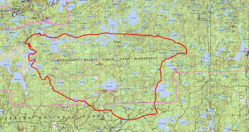
Map of the Pagami Creek fire. Sawbill is on the far right. The fire made it almost to Hazel Lake on the Lady Chain route. The south shore of Polly and Kawaschong Lake (just north of Kawishiwi Lake) burned. Otherwise, no other canoe routes in the Sawbill area have burned.