Posted on

Jerry Vandiver Brings Live Music to Sawbill

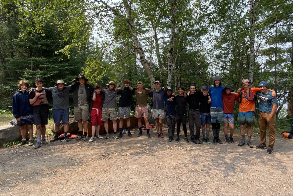
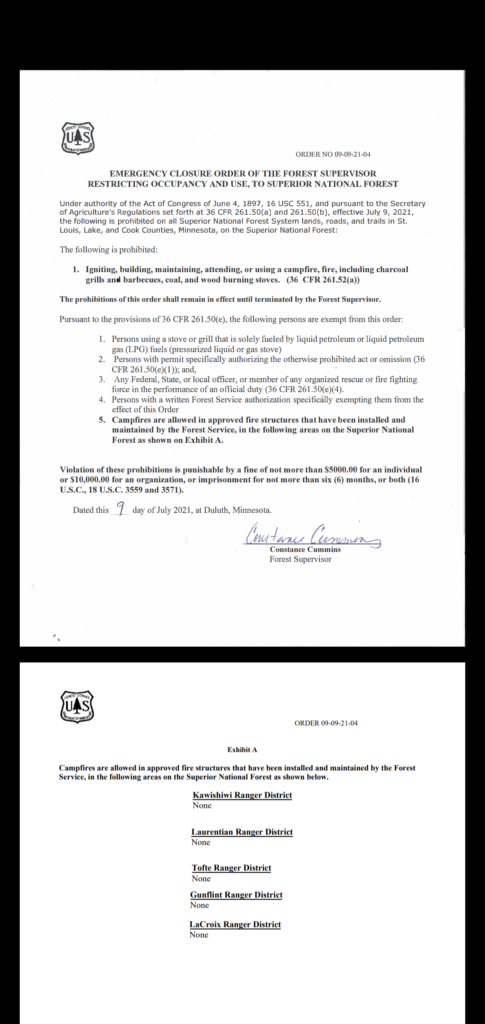
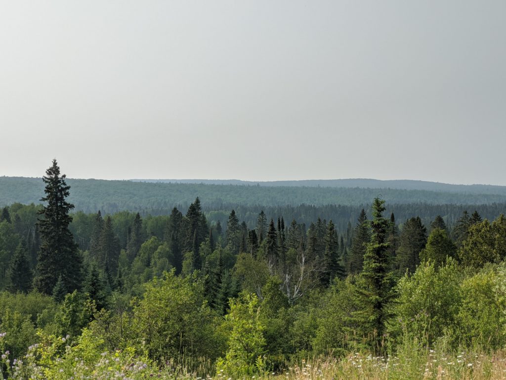
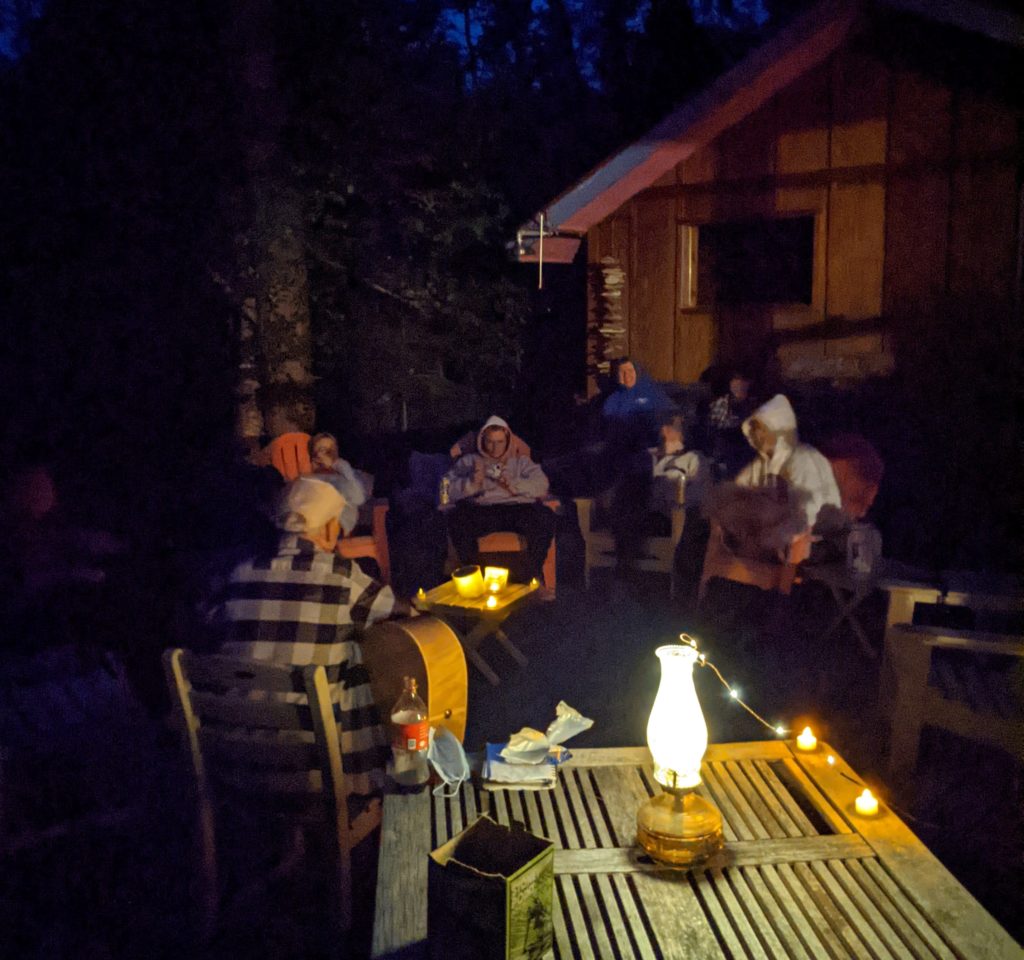
8/6/2021- Jerry Vandiver, an award-winning songwriter, musician, and longtime Sawbill enthusiast from Nashville, Tennessee, is up visiting Sawbill and the surrounding area. On August 4th, he played a small concert for the Sawbill crew — practicing his lineup of north country songs that he will be playing for our local radio station, WTIP on August 13 at 5:30 pm (tune in at wtip.org!) Due to the fire ban, the crew gathered around LED lights and battery-operated candles, and although it wasn’t the same as a real campfire, it had the same feel as a campfire gathering — with the added bonus of not having to constantly shift to avoid the smoke! Some of the crew’s favorite songs were “Too Many Boats” and “Not Enough to Bail.” Like many songwriters and artists, Jerry told the stories behind his songs, and it was enlightening for the crew to hear some of the behind-the-scenes workings of the music industry. The stories were followed by questions and laughs, leading to an overall fun night.

Jerry Vandiver plays on the back deck of the Shirley’s home

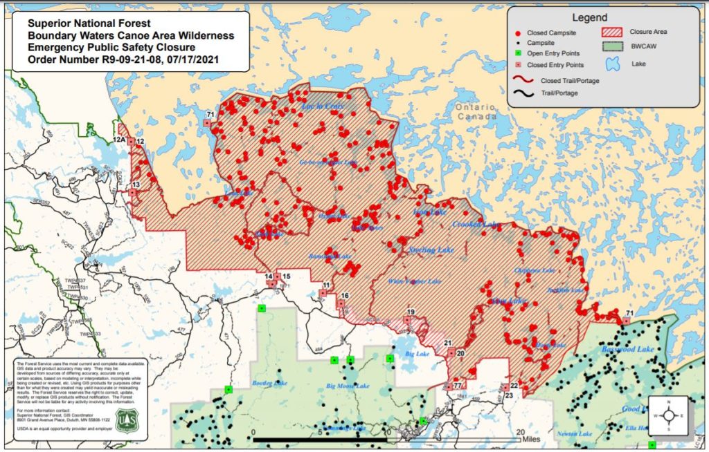
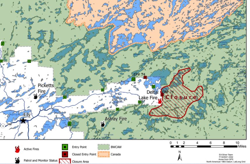
However, Jerry isn’t just here in Minnesota to entertain the Sawbill crew. Throughout August, during the times when he’s not playing music, Jerry will be taking trips throughout the BWCA. He has already completed the Cherokee Loop, and like many others, has reported the low water level in Cherokee Creek. He left again today for the wilderness, so if you see a solo paddler somewhere in the Sawbill region, singing and pretending to strum a guitar, you may have met the award-winning musician Jerry Vandiver.

-Robin

Posted on

Visitors from Temagami arrive at Sawbill

8/2/21 Heyo!

Today two groups from Northwaters and Langskid canoe camp (NWL camp for short), located in Temagami, Ontario came into Sawbill. They were on day 10 of a 20 day excursion into the BWCA. Between the two groups, there were 2 leaders and 15 kids ranging from ages 14-19. The two leaders, Garret (21) and Takoma (24) have both gone on many trips into the BWCA but many of the younger campers were fairly new to the experience. The campers came from all over the US, ranging from California to Tennessee! They all got into the NWL wilderness program through family and friends recommending the summer camp. Both groups started at Seagull lake and made their way down to Sawbill. The first portage that the groups did was the 500 rod portage from Seagull to Paulsen, and for many of the members, this was their first portage ever! The group leaders said that the kids are all doing fantastic out there in the wild, and overcoming all sorts of physical and mental challenges involved with camping. The groups are splitting up today, with Garret’s group heading towards Fowl lake and Takoma’s group heading towards Mcfarland lake. With high spirits and big smiles, the group set off from Sawbill to head back towards home at around noon today!

The two groups standing at the Sawbill landing after eating a well deserved meal of watermelon and cookies

-Ben

Posted on

Sawbill Air Quality and Water Level Update

8/1/21 – Heyo!

We have been getting lots of questions about air quality and water levels up here recently. With the camping season coming into full swing, lots of people are worried about very common routes such as the Lady Chain or the Cherokee loop being too low to pass. Currently, both of these routes are still passable but there will be times where you have to get out of your canoe and walk it through some shallow, rocky areas. Below I have more detailed descriptions of problem areas on each of these routes.

Cherokee Loop – The stretch from Ada creek all the way up into Cherokee lake is fairly low right now. When in Ada creek, make sure to take portages when you see them and be wary of rocks in the water. Cherokee creek is extremely low right now, so there are many spots where people will need to get out of the canoe and walk it through the creek. The bottom of the creek is mud, so when walking the canoe you may be knee-deep in muddy water. This is the only problem section of the Cherokee loop, the rest is easy sailing!

Lady Chain – The channels in and out of Knight lake are extremely low right now. People are reporting that it takes about an extra hour or two to navigate this area because of the amount of getting in and out of the canoe. Below is an image of the area West of Knight lake.

The area west of Knight Lake has lots of low spots like this where the canoe will need to be carried

Hog Creek – The Hog creek entry point is very low right now. The whole area is taking about twice as long as average to navigate.

Air Quality – The air quality varies day by day, but recently it has been very good! Most of the smoke and haze has cleared from the Sawbill area, so the sky is bright and blue again. Below is an image of the smoke plume map found at airnow.gov.

The grey area on the map indicates a smoke plume. Sawbill is the blue dot on the north end of Minnesota.

-Ben

Posted on

Fire and Food Storage

7/31/21 – As we slide into August in the northwoods, we are happy to report that the Beth Lake fire has been designated as “out” by the Forest Service. A quick response from firefighters and some key water drops from the helicopter resulted in little to no disruption to travel in the area. While two new small fires were detected in the BWCA yesterday, there remains no threat to the Sawbill area from any existing fires.

The air quality hasn’t been terrible, Kit and Huck are still enjoying their walks on the Sawbill Trail.

The drought has further reaching effects than just fire danger. A late season frost and the lack of rain has resulted in a very poor berry crop. The lack of natural foods has driven wildlife to seek food sources wherever they can. That, and the number of well-intentioned but un-informed campers bringing inappropriate food storage containers (think coolers) in the BWCA has resulted in some increased bear encounters. We have had very few reports of bears in the Sawbill area this season (only one instance of a bear getting into an unattended cooler on Pipe Lake), but other parts of the Wilderness are now dealing with “problem” bears who have been rewarded by easily stealing people food and are now seeking it out. As a result, there is now a food storage order issued by the Forest Service for the entire Superior National Forest, including the BWCAW.

The order states that visitors in the Forest must secure their food in one of two ways:

  1. Using a bear canister or bear-resistant container and securing it at least 50 feet away from your tent; or
  2. Hanging your food pack at least 12 feet above the ground, and six feet horizontally from an pole or limb, and four feet vertically from any pole or limb.

While these are always the best practices, the fact that it is now an order means you can be ticketed and fined for not following these protocols. Leaving a cooler sitting out on your picnic table, even while you’re sitting nearby in your screen tent, could result in a ticket. If you are car camping, you should plan to store all your food in your hard-sided vehicle when you aren’t actively eating or cooking. Other ways to help avoid an unwanted bear encounter are to keep a clean campsite, make sure there are no fragrant foods spilled on the ground, keep your food condensed and packed in one place and secured whenever you aren’t using it, and clean and dispose of fish remains well away from your campsite. If you are camping in the Boundary Waters, DO NOT bring in a cooler. They are impossible to properly secure and very enticing for bears.

While we aren’t picking berries at our favorite patches this season, there are a few bushes around the campground that provide a sweet treat.

Here at Sawbill we secure our dumpsters at 9pm every night, and reopen them at 7am. This way, when we aren’t actively monitoring them overnight, the bears can’t help themselves to a smorgasbord of trash. Plan to dump your trash before 9pm, or keep it in your car until the next morning! Thanks to the diligence of our crew and visitors, we are glad to report no bear issues at Sawbill this season, but we’ll have to continue working together to keep it that way.

-Clare

Posted on

Beth Lake Fire

7/28/21 – On July 26th the Forest Service detected a small wildfire near the portage between Beth and Grace lakes, about 3 miles to the southwest of Sawbill. Over the last couple of days they sent in a crew of 4 firefighters, conducted aerial surveys of the fire, and utilized aircraft for water drops. They are describing the fire as smoldering in hardwood litter, and it has been kept to roughly 2 acres in size. As of this morning, we are glad to report that it is 40% contained. Weather conditions have been in our favor, with another .15″ of rain falling last night, and cool mornings, calm winds, and overcast humid days.

There are no closures or reroutes in the Sawbill area at this time. The portage between Beth and Grace is still open, and recent paddlers have reported no evidence of the fire, other than the occasional aircraft overhead.

Travelling in the BWCA during wildfire season requires an extra level of awareness. If you are camped or travelling through an area that comes under threat of a wildfire, the Forest Service Wilderness rangers will sweep through the area and contact you, showing you the safest route by which to exit. It is a good practice to carry maps on your trip that cover the area around your route, just in case your travel plans have to change.

We’ll be sure to update this newsletter as we get more information about any fires in the area. At this point we are feeling grateful for the quick response from the Forest Service and will keep crossing fingers and toes for a good solid downpour.

-Clare

Posted on

Fire Ban Update

7/21/21 – As of today, the fire ban is extended to the entirety of the Superior National Forest. This includes the BWCA Wilderness as well as the fee campgrounds like Sawbill, Crescent, Temperance. Here’s the order:

The last time we had any rain was June 27th, and we only received a total of 2.59 inches of rain here at Sawbill in June. Things are DRY. Most of the routes in our area are still navigable, but you may encounter areas where you need to walk along streams and float your canoe. I wouldn’t recommend heading into the Frost River at this point, but Cherokee Creek is still ok as long as you are comfortable getting your feet wet and muddy!

Vegetation is starting to show signs of strain. Leaves are changing colors and in some cases dropping from the trees.
A normally lush patch of ground is now a tinder box of dead plants and crispy pine needles.

We appreciate everyone’s diligence in keeping human caused fires out of the forest. Wilderness travel is always impacted by the conditions, so planning appropriately is important whether it’s a drought or thunderstorms. We continue to be very fortunate that there are no wildfires imminently threatening the Sawbill area. If that changes, we’ll post here and on social media right away. Thanks for hanging in there with us!

Clare

Posted on

New Crew

It’s mid-July and the whole Sawbill crew is officially here! This year the crew is split pretty evenly between returners and newcomers. Keep an eye out on our webpage this week as we update our “Meet the Crew” segment to learn about all of the crew members both old and new. For now, I’ll introduce the first-year Sawbill crew. We’re the rookies, the newbies, the ones who are still learning how to tie a good bear rope and wrangle three canoes to the top of a half-cab. We might be a little green yet, but we’re quickly learning the Sawbill ways and are so excited to be spending the summer in such a beautiful place!

Without further adieu, here is the new crew!

Ben

From: Minneapolis, Minnesota

Favorite lake in the BWCA: Saganaga

Favorite Sawbill memory so far: Trying to sail across Saganaga with Diana

Favorite pastimes: Lifting weights in the dome, watching skate videos, biking on forest roads, and talking to customers

Diana

From: Sartell, MN

Favorite lake in the BWCA: Saganaga

Favorite Sawbill memory so far: Looking at the stars at night

Favorite pastimes: Reading, playing with Huckleberry, and of course, paddling

Favorite and least favorite job at Sawbill: Washing the leeches

Emily

From: Duluth, Minnesota

Favorite lake in the BWCA: Knife Lake

Favorite Sawbill memory so far: Sunset swims with the crew

Favorite pastimes: Hiking, biking, reading

Favorite job at Sawbill: Working dome (outfitting) and meeting all of the different customers

Gabe

From: Cedar Falls, Iowa

Favorite lake in the BWCA: Little Saganaga

Favorite Sawbill memory so far: Paddles with friends

Favorite pastimes: Climbing and napping at Beach Club

Least favorite lake in the BWCA: Beth, she stole my glasses

Robin

From: Grand Marais, Minnesota

Favorite lake in the BWCA: Cherry

Favorite Sawbill memory so far: Sunset swims and rainy paddles

Favorite pastimes: Knitting, climbing, cross country skiing, canoeing, baking

Siri

From: Mount Horeb, Wisconsin

Favorite Lake in the BWCA: South Temperance

Favorite Sawbill memory so far: Paddling on Lake Superior for Ladies Night

Favorite pastimes: Reading, biking, skiing, hiking, and paddling

Favorite part about working store: Petting all of the dogs

Posted on

Fire FAQ

7/18/21 – We’re getting some phone calls about the current fire situation in the BWCA so I thought a wildfire FAQ was in order. Of course, the situation is changing from day to day, and we will continue to post updates here and on social media as the summer progresses.

Where are the fires? Currently, there are a number of wildfires burning in the Superior National Forest, as well as the Quetico Provincial Park across the border in Ontario. Below is a map that shows the location of the current fires, with the town of Ely marked for reference.

The red fire icons show active fires. Sawbill is off this map to the east.

Are any of these fires threatening the Sawbill area? The short answer is no. At the moment, these fires are all quite a ways from us, and there is no imminent threat to us from active fires.

Is there a fire ban? Yes. You cannot have campfires in the BWCA or Superior National Forest. Right now, you can still have a campfire in the designated fire ring at the Sawbill Lake, Crescent Lake, and Temperance River campgrounds. Looking into my crystal ball, I expect that the fire ban will extend to these campgrounds very soon. The fire ban means no campfires, no twig stoves, and no charcoal grills.

How will I know if a fire starts in the area while I’m out on a trip? If the area you are tripping in comes under threat of a wildfire while you are out there, the Forest Service Wilderness Rangers will enter the at-risk area and notify campers. You will be instructed to leave the area and shown the best route to do so.

Is the BWCA closed? There are two specific areas of the BWCA Wilderness that the Forest Service has closed, in an abundance of caution. These areas are at particular risk from current wildfires. Below is a map showing the closed areas.

This most recent closure extends from entry point 12 on the West to 71 on the East and borders Canada and Quetico Provincial Park.
This closure is due to the Delta Lake Fire, the town of Ely is marked on the West for reference.

Which entry points are closed? The following is a list of currently closed entry points:

  • Little Indian Sioux River North #14
  • Moose / Portage River #16
  • Stuart River #19
  • Angleworm Lake #20
  • South Hegman Lake #77
  • Little Vermilion Lake #12
  • Lac La Croix Only #12A
  • Blandin Trail #11
  • Herriman Lake Trail #13
  • Sioux-Hustler Trail #15
  • Angleworm Trail #21

If you have a permit for a closed entry point, you will get a refund for your permit. You are welcome to book a different permit for another entry point, although availability is quite limited. You can check for open permits on recreation.gov. We service the entry points in the Tofte District, primarily.

The Forest Service does not open up more permits for other entry points, the quota system remains the same as a regular year and once they are booked, that’s it. That said, there are opportunities for canoe camping within the Superior National Forest that are outside the BWCA and therefore do not require a permit. One option is the Timber Frear Loop, which is nearby Sawbill.

How smoky is it at Sawbill? There’s a significant haze in the air, that is persistent throughout the day and night. The smell of wildfire smoke is like no other, and is ever present these days.

Haze over the Temperance River valley at midday on July 16th.

What are water levels like? In a word, low. Routes in our area are still navigable, but the portage landings look at little different than usual. After speaking with groups who returned from Cherokee this morning, the word is that Cherokee Creek is low but navigable, with a few short areas that may require walking while floating the canoe.

Are the bears becoming a problem due to the drought and fires? We have had no reports of problem bears in the Sawbill area. No doubt, it is a rough year for bears and other wild life. Keep a clean camp, hang your food, and ask an outfitter in your area for updates on persistent problem bears.

If you have any other questions or concerns, please don’t hesitate to give us a call. We are answering the phones 7am – 9pm, seven days a week. We’re working hard to help folks have successful trips! Thank you for your continued support and conscientious efforts to protect and enjoy our favorite Wilderness area.

-Clare

Posted on

Have you ever seen the rain?

7/16/21- There has been quite a lack of rain this summer, and as such, it comes as no surprise that there has also been a high fire danger in the last month. These dry conditions are directly responsible for the fire restrictions in northern Minnesota that started on July 9th, 2021.

Follow this link to the Minnesota DNR’s website which shows fire risk and gives more information about fire restrictions. https://www.dnr.state.mn.us/forestry/fire/firerating_restrictions.html

You can also see what your drought level in your area looks like on this website https://www.drought.gov/states/minnesota

The drought has directly impacted our water levels, leaving certain rivers too low to pass in boats and left some of our plants small and crunchy. One of the plants we have seen affected is the blueberry! Our blueberry experts Clare and Lida have informed us that their private patches have been looking quite thirsty this year. We are hoping we will get more rain in the future so that we can all enjoy a sweet taste of summer in the Northwoods. In the meantime please remember to keep fires out of the BWCA and ensure your grated fires are small and use lots of water when putting them out.

Some frost and drought survivors! Grow berries, grow!
Hanging out with some of our bait!

Leeches are cool. In fact, I think most people let their appearance make a scary first impression but, as our resident Leech lover Kit Shirley says “Leeches deserve love too.” I too have fallen victim to running away from their shiny bodies but I have been working on understanding and appreciating these creatures. Leeches or Hirudirea are considered worms and they live on every continent on the planet except Antarctica, this includes giant amazon leeches that can be up to 18 inches long and live up to 20 years! Our BWCA wilderness has leeches living in the waters! They can be big or small and can be seen swimming in the water or attached to rocks and logs. If you are trying to avoid them hitching a ride we suggest tennis shoes or boots while portaging! (Facts from Mark E Siddall, a Parasite expert)

– Diana

Posted on

Oh Snap!

7/13/2021- One of the most exciting visitors of the season has been appearing on our shores. We are not sure what her name is but her presence is definitely noticed! She is a snapping turtle who is deciding if Sawbill is a safe enough place to lay her eggs! We understand how cool it can be to see these creatures on our shores but we ask you to take into consideration their feelings and personal space. We love our snapping turtles and encourage you to tell them a story, take pictures with them, and say hi but refrain from picking them up or touching their body. This helps keep the turtles safe and healthy and also ensures that everyone keeps all of their fingers!

Crew members Ben and Sawyer saying hello!

Snapping turtles are incredible creatures that can live more than 40 years! Their distinctive features include their large heads and necks which have blunt wart-like tubercles on them. Snappers typically build their nests in the summer and springtime. They choose dry, sandy areas and can lay between 20 and 40 eggs! These eggs take 60 to 65 days to incubate which means they generally hatch in mid-August.

More turtle facts pulled from https://www.cookmuseum.org:

  • Common Snapping Turtle’s scientific name is Chelydra serpentina. Chelydra is a Greek word that means “tortoise” and serpentina is derived from the Latin word serpentis, which means “snake”.  This word refers to its long tail.
  • They have powerful jaws and have an average bite force of 209 N. They may not have the same force that you do when you bite with your molars (1300 N) but they have enough force to do some real damage.
  • The Common Snapping turtle is an aquatic turtle that prefers slow-moving, shallow bodies of water with muddy bottoms, which give them places to hide.
  • They are omnivores, meaning they eat plants and animals.  Their diet consists of plants, insects, worms, snakes, fish and other small animals.
  • You can find the Common Snapping Turtle all the way from southeastern Canada to the southern tip of the Florida panhandle.

– Diana